Autonomous perception: how robots see the lunar surface.
Autonomous perception is the stack of cameras, lidar, spectrometers, and machine-learning models that lets a machine read terrain, classify material, and avoid hazards with no operator in the loop. It is the first layer of any self-sustaining off-world industry: nothing can be mined, moved, or built until a machine can see well enough to act on its own.
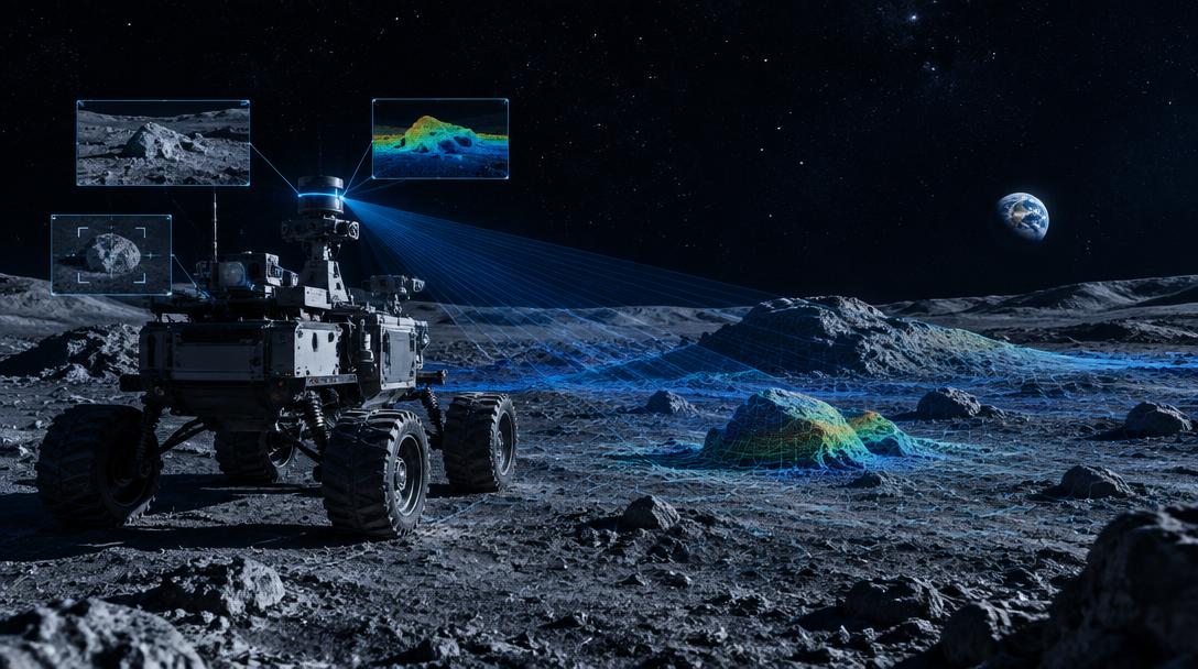
No joystick survives a 1.3-second delay.
Light takes about 1.3 seconds to travel between Earth and the Moon. Add processing and routing, and a human teleoperator is always steering a machine that has already moved on. For slow survey work that is awkward. For excavation, where a bucket meets buried rock at force, it is a non-starter.
The answer is not faster links. It is perception good enough that the machine never needs to ask. An autonomous excavator must decide, dozens of times per second, whether the ground ahead is load-bearing, whether the material in its scoop is worth keeping, and whether the shadow to the left is a rock or a pit.
That is a computer vision problem before it is a robotics problem, and it is why perception sits at the base of every autonomous off-world system worth building.
From photons to dig plans in four stages.
Cameras, lidar & spectrometers
Stereo cameras capture geometry, lidar measures range through darkness and dust, and spectrometers read surface composition. Together they turn raw terrain into structured data.
Terrain classification
Machine-learning models label every patch of ground: solid rock, loose regolith, ice-bearing shadow, or unstable slope. The machine knows what it is standing on before it commits weight.
Hazard & path planning
Perception feeds a planner that routes around craters, boulders, and soft soil, and selects dig sites with the highest expected yield per kilowatt-hour.
Continuous improvement
Every pass sharpens the model. Excavation outcomes are compared against predictions, so the system gets better at reading each new site it works.
The Moon is already mapped. The machines are not.
Decades of orbital mapping and surface missions have given us a rich picture of what the Moon offers: resource distributions, terrain maps, and composition data at resolutions that keep improving. The open question is no longer what is there. It is whether a machine can act on that knowledge alone, for years, with no operator in the loop.
Autonomy is what has to be proven, and Earth is where it can be proven affordably. Every test flight costs a launch, so iteration belongs in quarries, tailings fields, and open-pit mines, where dust, glare, shadow, and unstable slopes can be encountered daily at a fraction of the cost of a lunar sortie.
This is the logic behind Explural's excavation program. Autonomous mining on Earth generates revenue today while maturing exactly the autonomy stack an off-world system needs. When it flies, it arrives fluent in the language of terrain, ready to fuse with the lunar data we already hold. Perception is also the layer that compounds: better classification means better dig-site selection, more yield per unit of energy, and that is the constraint that decides whether in-situ resource utilization closes its business case at all.
Keep exploring.
How space propulsion works: a complete guide
Chemical, ion, nuclear, and beyond, the engines that move spacecraft, explained from first principles.
Read →
Living off the land on the Moon: an ISRU guide
How missions mine water, oxygen, fuel, and metals from lunar regolith instead of launching them from Earth.
Read →
Tritium vs. helium-3 for fusion energy
How the two leading fusion fuels compare on scarcity, yield, and why the Moon settles the debate.
Read →